Soft-Sediment Deformation: Recent Flood Evidence in Acts and Facts October 2013:1-17
"Evidence for Soft-Sediment Deformation by John D Morris (geologist)
The conventional dating assigned to the lowest Pliocene, marine sandstone of the Split Mountain Formation assumes an age of several million years. The age assigned to the soft-sediment deformation is middle or late Pleistocene—within the last million years. This dating system assumes that sediments, in a state of deep burial, stayed soft and pliable for millions of years or that the hard, brittle rocks bent with virtually no breaking or cracking! The rocks, however, tell us a different story—one in which the recent global Flood laid down immense deposits of sediments in a short amount of time. Soon after, the subsequent folding of these sediments, while they were still unlithified, produced the dramatic deformation we observe today. God’s hand was in the Flood event…the rocks bear witness to this cataclysm and still speak to us today." See article at link below.
The conventional dating assigned to the lowest Pliocene, marine sandstone of the Split Mountain Formation assumes an age of several million years. The age assigned to the soft-sediment deformation is middle or late Pleistocene—within the last million years. This dating system assumes that sediments, in a state of deep burial, stayed soft and pliable for millions of years or that the hard, brittle rocks bent with virtually no breaking or cracking! The rocks, however, tell us a different story—one in which the recent global Flood laid down immense deposits of sediments in a short amount of time. Soon after, the subsequent folding of these sediments, while they were still unlithified, produced the dramatic deformation we observe today. God’s hand was in the Flood event…the rocks bear witness to this cataclysm and still speak to us today." See article at link below.
CATASTROPHIC PLATE TECTONICS:
THE PHYSICS BEHIND THE GENESIS FLOOD
by Dr John Baumgardner
"Presented: Fifth International Conference on Creationism
August 4-8, 2003
Copyright 2003 by Creation Science Fellowship, Inc.
Pittsburgh, PA USA - All Rights ReservedJOHN R. BAUMGARDNER, PH.D.ABSTRACT The wealth of new data, mostly from the ocean bottom, that precipitated the acceptance of plate tectonics during the 1960’s simultaneously also opened the door for the first time in more than 200 years to a technically credible defense of the Genesis Flood. From the mid-1700’s through the days of Hutton, Lyell, and Darwin to the 1960’s, it overwhelmed the human mind to imagine a mechanism that could possibly deliver, in a single brief event, the magnitude and complexity of geological change evident in the continental rock record above the point where fossils first appear. However, with the new awareness that the Earth’s interior could participate in the process and that the stiff layer of rock some 50 miles thick beneath the oceans could be recycled into the Earth, the stage was set for a breakthrough in regard to the mechanism for the Flood cataclysm. The crucial final piece of the puzzle has come from laboratory experiments that have carefully measured the way in which silicate minerals deform under conditions of high temperature and high stress. These experiments reveal silicate material can weaken dramatically, by factors of a billion or more, at mantle temperatures and for stress conditions that can exist in the mantles of planets the size of the Earth. The scenario in which all the Earth’s ocean lithosphere is rapidly recycled into the mantle via a runaway process, enabled by this stress-weakening behavior, is now known as catastrophic plate tectonics." See link below for more information.
Computer Modeling of Large Scale Tectonics Associated with the Noah Flood by Dr John Baumgardner
ABSTRACT
"Any comprehensive model for earth history consistent with the data from the Scriptures must account for the massive tectonic changes associated with the Genesis Flood. These tectonic changes include significant vertical motions of the continental surfaces to allow for the deposition of up to many thousands of meters of fossil-bearing sediments, lateral displacements of the continental blocks themselves by thousands of kilometers, formation of all of the present day ocean floor basement rocks by igneous processes, and isostatic adjustments after the catastrophe that produced today's Himalayas, Alps, Rockies, and Andes. This paper uses 3-D numerical modeling in spherical geometry of the earth's mantle and lithosphere to demonstrate that rapid plate tectonics driven by runaway subduction of the pre-Flood ocean floor is able to account for this unique pattern of large-scale tectonic change and to do so within the Biblical time frame." See Link below for further information.
"Any comprehensive model for earth history consistent with the data from the Scriptures must account for the massive tectonic changes associated with the Genesis Flood. These tectonic changes include significant vertical motions of the continental surfaces to allow for the deposition of up to many thousands of meters of fossil-bearing sediments, lateral displacements of the continental blocks themselves by thousands of kilometers, formation of all of the present day ocean floor basement rocks by igneous processes, and isostatic adjustments after the catastrophe that produced today's Himalayas, Alps, Rockies, and Andes. This paper uses 3-D numerical modeling in spherical geometry of the earth's mantle and lithosphere to demonstrate that rapid plate tectonics driven by runaway subduction of the pre-Flood ocean floor is able to account for this unique pattern of large-scale tectonic change and to do so within the Biblical time frame." See Link below for further information.
RUNAWAY SUBDUCTION AS THE DRIVING MECHANISM FOR THE GENESIS FLOOD by Dr John Baumgardner
ABSTRACT
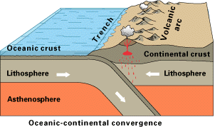
"Experimental investigation of the solid state deformation properties of silicates at high temperatures has revealed that the deformation rate depends on the stress to a power of about 3 to 5 as well as strongly on the temperature. This highly nonlinear behavior leads to the potential of thermal runaway of the mantle's cold upper boundary layer as it peels away from the surface and sinks through the hot mantle. The additional fact that the mineral phase changes that occur at 660 km depth act as a barrier to convective flow and lead to a tendency for large episodic avalanche events compounds the potential for catastrophic dynamics. Two-dimensional finite element calculations are presented that attempt to model these strongly nonlinear phenomena. It is proposed that such a runaway episode was responsible for the Flood described in Genesis and resulted in massive global tectonic change at the earth's surface." See Link below for further information. Image below from Wikipedia 4-27-15 public domain.
"Experimental investigation of the solid state deformation properties of silicates at high temperatures has revealed that the deformation rate depends on the stress to a power of about 3 to 5 as well as strongly on the temperature. This highly nonlinear behavior leads to the potential of thermal runaway of the mantle's cold upper boundary layer as it peels away from the surface and sinks through the hot mantle. The additional fact that the mineral phase changes that occur at 660 km depth act as a barrier to convective flow and lead to a tendency for large episodic avalanche events compounds the potential for catastrophic dynamics. Two-dimensional finite element calculations are presented that attempt to model these strongly nonlinear phenomena. It is proposed that such a runaway episode was responsible for the Flood described in Genesis and resulted in massive global tectonic change at the earth's surface." See Link below for further information. Image below from Wikipedia 4-27-15 public domain.
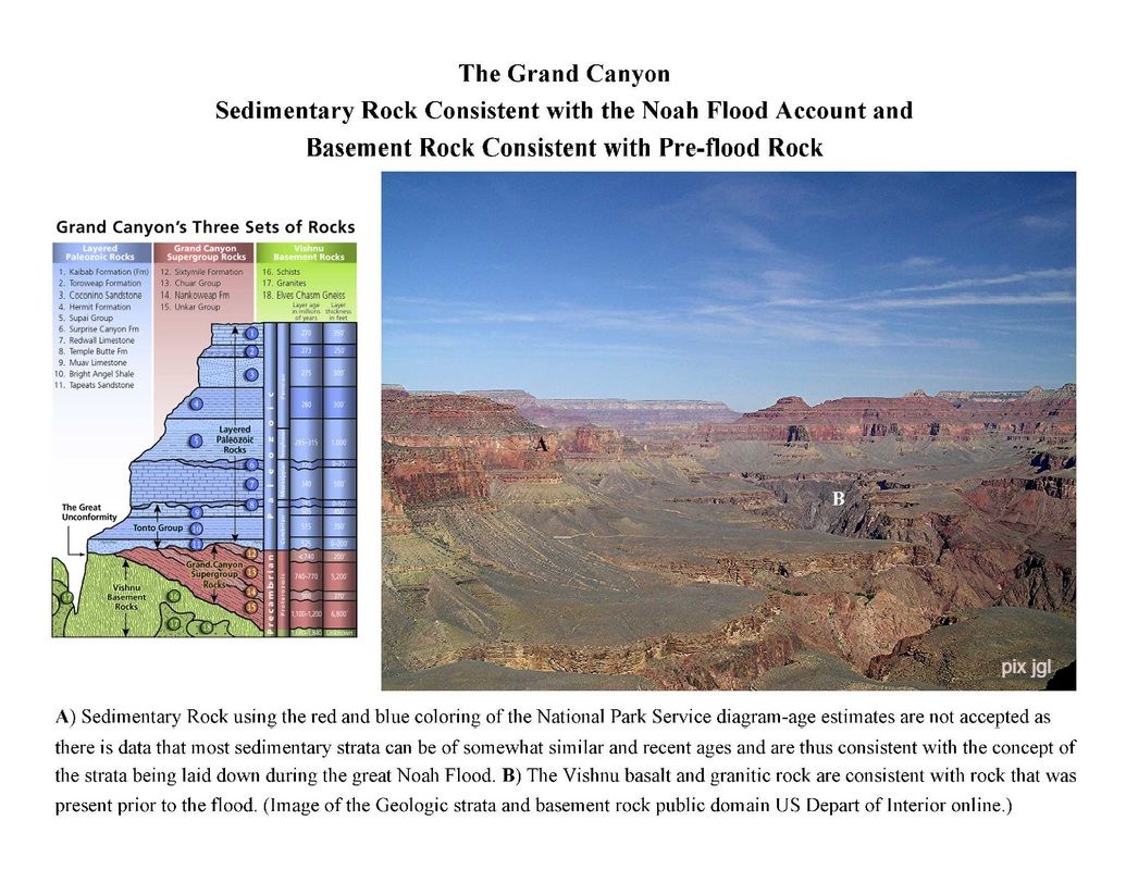
The Geologic Column with Gaps Observed in the Grand Canyon by John D Morris ICR Feb. 2012. Click button below.
"If the old earth view is correct, then the record is woefully incomplete. Grand Canyon strata are all “dated” in the supposedly 300 million-year-long Paleozoic Era, but of the seven periods within that era, only five are represented in Grand Canyon. More importantly, if the upper and lower surfaces of each stratum are dated by questionable uniformitarian means and plotted on a vertical line showing the entire Paleozoic Era, less than ten percent of the total time postulated by evolutionists is represented! It better represents brief episodes of deposition within the great Flood of Noah’s day." See Link below for more information.(Diagram above of Grand Canyon strata is used with permit from the National Park Service. Of course the list of age of strata is not accepted by myself-see section on evidence for young age of earth.)
Grand Canyon: Strata Consistent with the Noah Flood and Basement Rock Consistent with Pre-flood Granite
Mogollon Rim-Arizona Stratified Rock 8,000 Feet above Sea Level
'The Rim is an escarpment defining the southwestern edge of the Colorado Plateau, and along its central and most spectacular portions is characterized by high limestone and sandstone cliffs, namely the Kaibab Limestone and Coconino Sandstone. It was formed by erosion and faulting, and dramatic canyons have been cut into it, including Fossil Creek Canyon and Pine Canyon. The name Mogollon comes from Don Juan Ignacio Flores Mogollón, the Spanish Governor of New Mexico from 1712 to 1715.
Much of the land south of the Mogollon Rim lies 4,000 to 5,000 feet (1,200 to 1,500 m) above sea level, with the escarpment rising to about 8,000 ft (2,400 m)." From Wikipedia online 10-2014.
Much of the land south of the Mogollon Rim lies 4,000 to 5,000 feet (1,200 to 1,500 m) above sea level, with the escarpment rising to about 8,000 ft (2,400 m)." From Wikipedia online 10-2014.
Examples of Stratified Rock Apparently Rapidly Laid Down With Subsequent Massive Errosion
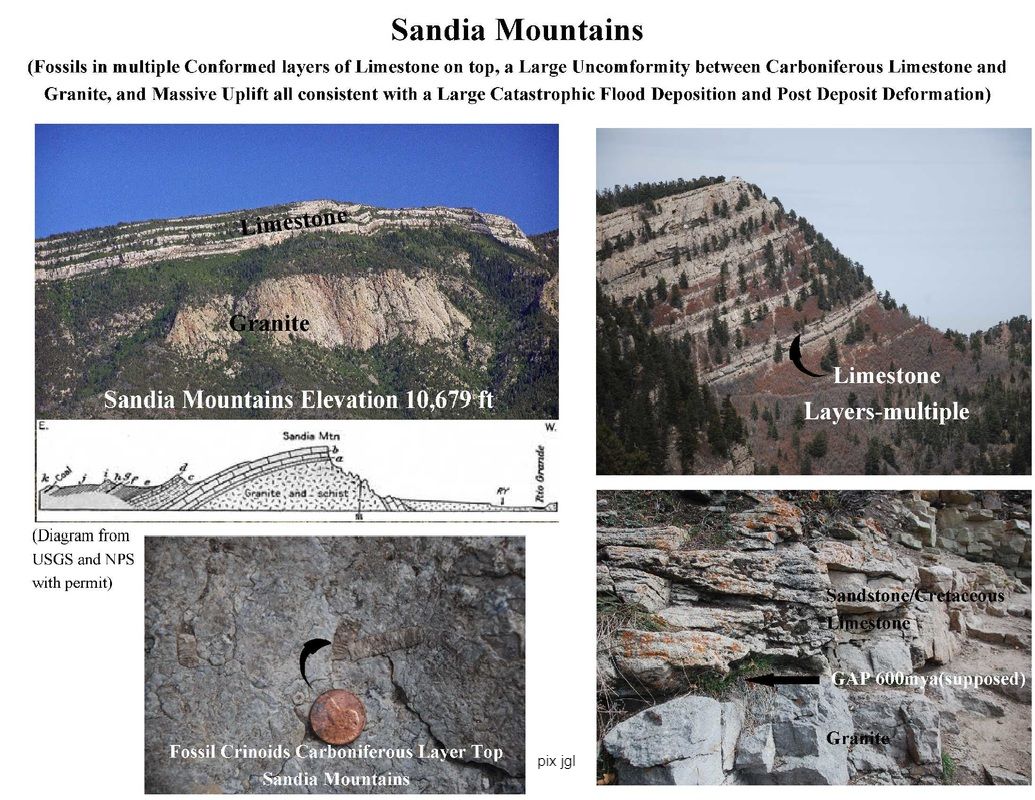
An Example of Evidence Consistent with a Massive Flood Deposition and Post Flood Deformation: Fossil Strata at 10,679 ft above sea level, with a Large (Great) Unconformity gap in strata of a supposed 600 million ya-1.1 Billion ya, and a large Uplift: The Sandia Mountains in New Mexico
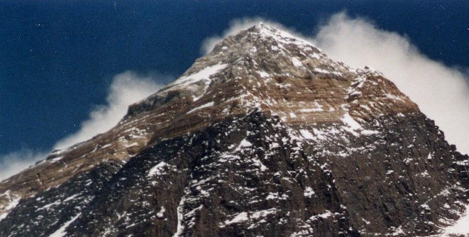
Mount Everest: An Example of Massive Flooding and post-Flood Tremendous Uplifting
"Geologists have subdivided the rocks comprising Mount Everest into three units called 'formations.'
1) “The Qomolangma Formation…runs from the summit to the top of the Yellow Band, about 8,600 m (28,200 ft) above sea level. It consists of grayish to dark gray or white, parallel laminated and bedded, Ordovician limestone inter layered with subordinate beds of recrystallised dolomite with argillaceous laminae and siltstone…petrographic analysis of samples of the limestone from near the summit revealed them to be composed of carbonate pellets and finely fragmented remains of tribolites, crinoids, and ostracods…(another) bed, which crops out starting about 70 m (230 ft) below the summit of Mount Everest, consists of sediments trapped, bound, and cemented by the biofilms of micro-organisms, especially cyanobacteria, in shallow marine waters…The lower five meters of the Qomolangma Formation overlying this detachment are very highly deformed…”
2) “The North Col Formation, of which the Yellow Band forms its upper part between 8,200 to 8,600 m (26,900 to 28,200 ft). The Yellow Band consists of intercallated beds of Middle Cambrian diopside-epidote-bearing marble, which weathers a distinctive yellowish brown, and muscovite-biotite phyllite and semi-shist…remainder of the North Col Formation, exposed between 7,000 to 8,200 m (23,000 to 26,900 ft) on Mount Everest, consists of interlayered and deformed schist, phyllite, and minor marble…lower part of the North Col Formation consists of biotite-quartz schist intercalated with epidote-quartz schist, biotite-calcite-quartz schist, and thin layers of quartzose marble. These metamorphic rocks appear to be the result of the metamorphism of Middle to Early Cambrian deep sea flysch composed of interbedded, mudstone,shale, clayey sandstone, calcareous sandstone, graywacke, and sandy limestone.”
3) “The Rongbuk Formation underlies the North Col Formation and forms the base of Mount Everest. It consists of sillimanite-K-fieldspare grade schist and gneiss intruded by numerous sills and dikes of leucogranite…”
“Mount Everest consists of sedimentary and metamorphic rocks that have been faulted southward over continental crust composed of Archean granulites of the Indian Plate during the Cenozoic collision of India with Asia…the Qomolangma and North Col formations consist of marine sediments…”
From Wikipedia online 5-11-16 ; Picture of Mt. Everest CC BY-3.0 File:EverestfromKalarPatarcrop.JPG Uploaded: 24 January 2014 -Uwe Gille 11:54, 26 Apr 2005 (UTC)


